ၾၢႆႇ:West Philippine Sea.svg

Size of this PNG preview of this SVG file: 384 × 599 ၽိၵ်ႉသႄႇလ်. resolutionsတၢင်ႇဢၼ် : 154 × 240 ၽိၵ်ႉသႄႇလ် | 307 × 480 ၽိၵ်ႉသႄႇလ် | 492 × 768 ၽိၵ်ႉသႄႇလ် | 656 × 1,024 ၽိၵ်ႉသႄႇလ် | 1,313 × 2,048 ၽိၵ်ႉသႄႇလ် | 507 × 791 ၽိၵ်ႉသႄႇလ် ။
ၾၢႆႇငဝ်ႈတိုၼ်း (ၾၢႆႇ SVG, ၸိုဝ်ႈ 507 × 791 pixels, သႅၼ်းၾၢႆႇ : 766 KB)
ၵႂၢမ်းယေႃး
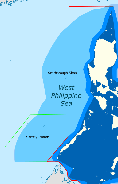
| ၶေႃႈသပ်းလႅင်း | Map showing the area in the South China Sea which roughly correspond to the "West Philippine Sea" |
| ဝၼ်းထီႉ | (UTC) |
| ငိူၼ်ႈငဝ်ႈတိုၼ်း |
This file was derived from: |
| ၽူႈတႅမ်ႈလိၵ်ႈ |
|


| This is a retouched picture, which means that it has been digitally altered from its original version. The original can be viewed here: Ph Territorial Map.png:
|
ဝ်ႂ
ၾၢႆႇဢၼ်ၼႆႉၼႆႉ မီးသုၼ်ႇဝႂ် ပႃႈတႂ်ႈ ၶွင် Creative Commons Attribution-Share Alike 3.0 Unported ဝႆႉၼႆႉ။
- ၸဝ်ႈၵဝ်ႇထၢင်ႇႁၢင်ႈ
- တႃႇၽႄၸႂ်ႉ – တွၼ်ႈတႃႇထုတ်ႇဢဝ်၊ ပိုၼ်ၽႄႈ လႄႈ ပိုၼ်ဢွၵ်ႇပၼ် ၼႃႈၵၢၼ်။
- ၶိုၼ်းထႅမ်သႂ်ႇ – မႄးထွင်ၵၢၼ် ႁႂ်ႈသၢင်ႇထုၵ်ႇ
- ၸွမ်းၼင်ႇ သၢႆႇငၢႆတီႈတႂ်ႈၼႆႉ
- ႁၢင်ႈၽၢင်ၶဝ်ႈပႃး – ၸဝ်ႈၵဝ်ႇတေလႆႈမွၵ်ႇပၼ်ၸိုဝ်ႈ ဢၼ်သၢင်ႇထုၵ်ႇ တွၼ်ႈတႃႇ လိင်ႉၶ် ဢၼ်ၵမ်ႉထႅမ်ပၼ် ဝႂ်ၶႂၢင်း လႄႈ သင်ၸိူဝ်ႉဝႃႈ လႆႈမီးလွင်ႈလႅၵ်ႈလၢႆႈမႃးၼႆ ၶႅၼ်းတေႃႈ ၸီႉၼႄပၼ်သေၵမ်း။ ၸဝ်ႈၵဝ်ထုၵ်ႇလီႁဵတ်း ႁႂ်ႈပဵၼ်တၢင်းႁဵတ်းသၢင်ႈ မီးလွင်ႈမီးတၢင်းမၼ်း၊ ၵူၺ်းၵႃႈဝႃႈ မၼ်းဢမ်ႇမၢႆထိုင်ဝႃႈ ဝႂ်ၶႂၢင်းၼၼ်ႉ မၼ်းတေပဵၼ် ဢၼ်ၸွႆႈဢၼ်ၵမ်ႉထႅမ်ပၼ် ၸဝ်ႈၵဝ်ႇ ဢမ်ႇၼၼ် ဢၼ်ၸဝ်ႈၵဝ်ႇၸႂ်ႉဝႆႉၼၼ်ႉ။
- သျေး ဢၼ်မိူၼ် – သင်ၸိူဝ်ႉဝႃႈ ၸဝ်ႈၵဝ်ႇ ၶိုၼ်းလေႃး၊ လႅၵ်ႈလၢႆႈ၊ မႄးၶိုၼ်း ဢမ်ႇၼၼ် ၵေႃႇသၢင်ႈ ၵႃႈတီႈၼိူဝ် ၼႃႈၵၢၼ်ၼႆႉၸိုင်၊ ၸဝ်ႈၵဝ်ႇ တေလႆႈဢဝ် လွင်ႈၸွႆႈသၢင်ႈၸဝ်ႈၵဝ်ႇၼႆႉ ပိုၼ်ၽႄႈ ၽၢႆႇတႂ်ႈ မိူၼ်ၼင်ႇ ဢမ်ႇၼၼ် ဝႂ်ငမ်ႇမႅၼ်ႈ ၼင်ႇ ငဝ်ႈတိုၼ်းမၼ်းၼၼ်ႉယဝ်ႉ။
Original upload log
This image is a derivative work of the following images:
- File:South China Sea location map.svg licensed with Cc-by-sa-3.0, Cc-by-sa-3.0-de
- 2011-08-17T18:56:31Z NordNordWest 1134x1229 (631729 Bytes) == {{int:filedesc}} == {{Information |Description= {{de|Positionskarte des [[:de:Südchinesisches Meer|Südchinesischen Meers]]}} Quadratische Plattkarte, N-S-Streckung 102 %. Geographische Begrenzung der Karte: * N: 25.5° N
- File:Ph Territorial Map.png licensed with Cc-by-2.5, GFDL
- 2015-07-19T05:58:17Z Schadow1 1827x1877 (627018 Bytes) Extending EEZ boundaries to include Benham Rise Extended EEZ and Philippines-Indonesia EEZ Delimitation Agreement
- 2012-05-08T11:33:56Z Sky Harbor 1827x1790 (547714 Bytes) Reverted to version as of 16:54, 28 August 2009. The name "West Philippine Sea" is a neologism and is not neutral.
- 2012-05-04T08:13:30Z Jeromesandilanico 612x600 (131658 Bytes) Change of name as West Philippine Sea as used to describe the Philippines official claim as used by the Philippine Government and Media.
- 2009-08-28T16:54:58Z Mormegil 1827x1790 (547714 Bytes) {{Information |Description= {{en|Territorial map of the [[Philippines]], showing internal waters, territorial sea, international treaty limits and exclusive economic zone.}} |Source=[[:en:File:Ph Territorial Map.png|English W
Uploaded with derivativeFX
ပိုၼ်းၾၢႆႇ
တဵၵ်းၼိူဝ် ဝၼ်းထိ/ၶၢဝ်းယၢမ်း တႃႇႁၼ်ၾၢႆႇ ၼႂ်းဝၼ်းၼၼ်ႉ
| ဝၼ်းထီႉ/ၶၢဝ်းယၢမ်း | ႁၢင်ႈလဵၵ်ႉ | သႅၼ်းမၼ်း | ၽူႈၸႂ်ႉတိုဝ်း | တၢင်းႁၼ်ထိုင် | |
|---|---|---|---|---|---|
| ယၢမ်းလဵဝ် | 16:05, 19 ဢေႇပရႄႇ 2024 | | 507 × 791 (766 KB) | Hariboneagle927 | International Treaty Limits + KIG border often included in NAMRIA maps |
| 00:29, 10 ဢေႇပရႄႇ 2021 |  | 507 × 791 (765 KB) | Hariboneagle927 | adjust color | |
| 00:21, 10 ဢေႇပရႄႇ 2021 |  | 507 × 791 (761 KB) | Hariboneagle927 | == {{int:filedesc}} == {{Information |Description= |Source={{Derived from|South China Sea location map.svg|Ph Territorial Map.png|display=50}} |Date=2021-04-10 00:21 (UTC) |Author=* File:South China Sea location map.svg: NordNordWest * File:Ph Territorial Map.png: '''PLEASE COMPLETE AUTHOR INFORMATION''' * derivative work: [[User:{{subst:REVISIONUSER}}|{{subst:REVISIONUSER}}]] |Permission= |other... |
လွင်ႈၸႂ်ႉတိုဝ်း ၾၢႆႇ
ၼႃႈလိၵ်ႈ ၵွင်ႉမႃးၸူးၾၢႆႇၼႆႉ:
လွင်ႈၸႂ်ႉတိုဝ်းၾၢႆႇလူမ်ႈၽႃႉ
Wikis ၸိူဝ်းဢၼ်ၸႂ်ႉဝႆႉ ၾၢႆႇဢၼ်ၼႆႉ:
- ၸႂ်ႉဝႆႉ bcl.wikipedia.org
- ၸႂ်ႉဝႆႉ en.wikipedia.org
- ၸႂ်ႉဝႆႉ fr.wikipedia.org
- ၸႂ်ႉဝႆႉ id.wikipedia.org
- ၸႂ်ႉဝႆႉ incubator.wikimedia.org
- ၸႂ်ႉဝႆႉ pt.wikipedia.org
- ၸႂ်ႉဝႆႉ tl.wikipedia.org
- ၸႂ်ႉဝႆႉ www.wikidata.org